Registered with the Registrar of Newspapers for India under R.N.I 53640/91
Vol. XXVII No. 16, December 1-15, 2017
Shrinking wetlands, felling trees
Putting Chennai at risk
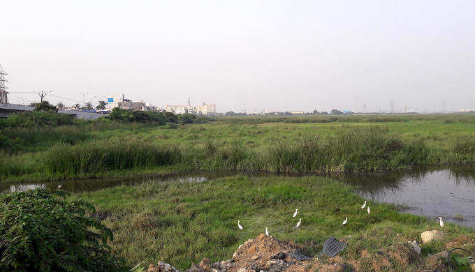
The Pallikaranai marsh in the southern part of the city with streams draining into it. (Photo by S. Gopikrishna Warrier)
Chennai has lost much of its climate resilience due to the shrinking of its wetlands and forest patches, which has drastically reduced the city’s ability to soak up excess rainwater writes S. Gopikrishna Warrier.
It is the network of blue and green that provides climate resilience to Chennai city – blue of its wetlands and green of its patches of vegetation. However, this combination that had been protecting the city in the past is today under stress. The shrinking of blue and green has drastically reduced Chennai’s ability to deal with extreme weather events.
Just 15 months after a massive flood in November-December 2015 battered the city, the residents suffered a serious drought during the summer of 2017. Even while sporadic rains over the city since the onset of the Southwest Monsoon in June 2017 have given respite from the drought, residents fear that there could be flooding with the Northeast Monsoon.
Chennai, which receives up to 60 per cent of its annual rainfall from the Northeast Monsoon expects this year’s rains to be at least average or better than that. With the city’s ability to deal with intense rains decreasing, there are chances of waterlogging and floods. Even by its very nature, the Northeast Monsoon that brings rains to Chennai is different to the Southwest Monsoon. The Northeast Monsoon is mostly a string of depressions or cyclones, which bring heavy rain over a few days. The destruction caused by the 130 km per hour winds and rains of Cyclone Vardah in December 2016 only adds to the fear of citizens.
“Unless the city’s landscape is resilient, the people cannot be resilient,” says Jayshree Vencatesan, managing trustee of Care Earth Trust. “We are only coping because there is no other choice. Each extreme weather event hits us hard.”
Using historical geo-spatial data, Care Earth Trust has developed maps that show the relationship of water bodies to built-up area in the city and the green cover within the city. As the blue (of the wetlands and water bodies) and green (vegetation cover) decreased in the past three decades over the Chennai metropolitan area, the red of built up area increased.
“Under the resilience framework, megacities are characterised as uncertain environments,” says Vencatesan. “We do not know whether climate change is causing the uncertainty or whether our messing up of the city’s environment is causing it.”
The development of the maps is part of a process to understand Chennai’s landscape and environment, according to her. There is inadequate data and insufficient understanding of the land use changes in the city and where population density is increasing. As a result, there is lack of clarity on the consequences of that change, especially with the ability to deal with extreme weather events. “We don’t have the detailed nuts and bolts understanding, and unless we have the data, our ability to deal with the situation is also not there,” Vencatesan adds.
There is evidence of increasing frequency of extreme rainfall events (EREs) not just in Chennai but also across India, even though their direct link with climate change is still considered tenuous. The 2012 special report on extreme events by the Intergovernmental Panel on Climate Change (IPCC-SREX) stated this for the first time to policymakers.
Since there are indications of an increasing trend in EREs over Chennai, the network of wetlands and forests is important to provide resilience against such extreme weather events. These have been part of the natural landscape over which the city was built with rapid speed in recent decades.
For a coastal city with an almost level gradient, wetlands and forests serve as the points from which water recharges into the aquifer. They act like sponges on the city floor. The four rivers that run from west to east across the city – Araniyar, Kosasthalaiyar, Cooum and Adyar – serve as the drainage channels for excess stormwater to flow into the sea. This network is complemented by the Buckingham Canal, which runs north to south across the city, and other smaller canals.
“The rivers and canals of Chennai have a clear role as flood control channels,” says Paul Appasamy, former Director of the Madras School of Economics. “The natural hydrology of the city was forgotten and haphazard construction and development was done on the banks of the waterways obstructing their flow. This amplified the flooding of end-2015.”
There is an added obstruction to the flow of floodwater into the sea. Both the Cooum and Adyar have sand banks at their mouths. Construction of the sea wall for the Chennai Port in the northern part of the city has resulted in coastal erosion north of the structure and accretion south of it. Thus, over recent decades, while the sea has eroded in north Chennai, swallowing fishing hamlets and old temples, the Marina Beach has been growing in width.
The very same process has been building sand banks, obstructing the flow of the Cooum and Adyar into the sea.
It was the loss of the wetlands and forest patches that drastically reduced the city’s ability to soak excess rainwater and use it during the lean months. Since the opening of TIDEL Park in 2000, the city has radiated out through a southern axis almost all the way to Mamallapuram. This has been at the expense of a network of wetlands that ultimately drained into the Pallikaranai marsh.
According to Vencatesan, there were almost 50 water bodies that were linked to the Pallikaranai marsh through a network of cascading channels. Many of them have been built over. The natural forests along their banks have also been removed. Radial roads that connect the Old Mahabalipuram Road with the Chennai-Trichy highway have bisected the Pallikaranai marsh along multiple axes. Embankments were created across the marsh to build these roads, thereby disturbing the natural flow dynamics in the marsh.
“The wetlands in Chennai are like the arteries and veins of the city,” observes Ritesh Kumar, conservation programme manager, Wetlands International South Asia. “These have been under tremendous stress from development pressures in the past two decades and have been losing their ability to hold water when needed and control floods during heavy rains.”
He feels that the Wetland Conservation and Management Rules (2017), notified by the Union Ministry of Environment, Forests and Climate Change on September 26, 2017, can help conserve the remaining wetlands. “There are two points of strength for the new rules. First, it gives powers to State governments to identify wetlands (which are not protected areas already) and develop conservation and management plans and implement them. Two, it stresses the principle of wise use for these wetlands. Most of the wetlands are not ‘no go’ areas, and they can be conserved and managed in a sustainable manner through wise use.”
The flood of end-2015, followed by Cyclone Vardah and the drought this summer, has given Chennai residents a sense of what it would be like to live through a string of extreme weather events. In some locations there has been civil society action, supported by organisations and governmental institutions, to conserve and rejuvenate water bodies. Perhaps these could be the initial steps in the process to stengthen Chennai’s climate resilience where the network of blue and green holds the key.