Registered with the Registrar of Newspapers for India under R.N.I 53640/91
Vol. XXVIII No. 5, June 16-30, 2018
A wealth of detail in an 18th Century map
 Dr. A. Raman (anant@raman.id.au) sends me this 18th Century map and note of Madras, done by a French Cartographer 15 years after the French quit the city. It is immaculate in details of what existed within the walls of the Fort. Raman writes:
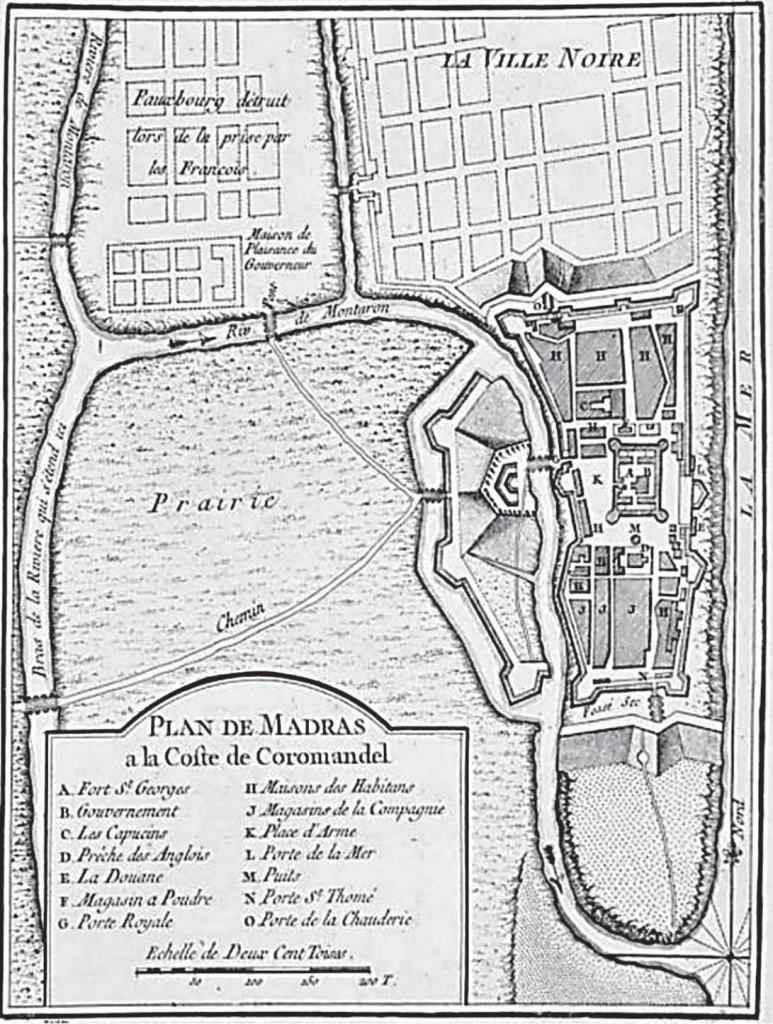
Jacques-Nicholas Bellin, whose map of Fort. St. George (i.e., Madras) in le Petit Atlas Maritime Recueti de Cartes et Plans des Quatre Parlies du Monde (Vol. III), dated 1764, is stunning in terms of accuracy and the attention to details. It lists:
J.-N. Bellin’s Map of the Fort St. George and Madras (1764). Fort. St. George (A) Fort St. George. Gouvernement (B) – Principal offices of the government. Les Capuchins (C) – Residence of Friars (minor Capuchin priests). Prêche des Anglais (D) – English (Protestant) chapel. La Douane (E) – Customs office. Magasin à Poudre (F) – Gun-powder warehouse. Porte Royale (G) – Grand gate. Maisons des habitans (H) – Residences. Magasins de le compagnie (J) – EEIC Company stores. Place d’Arme (K) – Army station. Porte de la Mer (L) – Sea-facing gate. Puits (M) – an ornate fountain. Porte St. Thomé (N) – St. Thomas Gate. Porte de la Chauderie (O) – Chauderie could not be deciphered but likely Choultry Gate. Riv. (Rivière) de Montaron – River Cooum. La ville noire – Native Indian town. La Mer – Bay of Bengal. Prairie – grassland. Chemin – road. Fauxbourg détruit lors de la prise par les François – Dilapidated residential suburb, because of the French army attack of Madras, led by Bertrand-François Mahé de la Bourdonnais in 1746. Maison de pleasance du Gouverneur – Governor’s summer house.
EDITOR’S NOTE: Why a French commune’s name was given to the Cooum is a bit of a mystery.