Registered with the Registrar of Newspapers for India under R.N.I 53640/91
Vol. XXV No. 18, January 1-15, 2016
Our Readers Write
Waterways and their care
I was reading the New York Times recently when I came across an obit about a man who had led in setting up an organisation named ‘Waterkeeper Alliance.’ It seems to be relatively widespread and appears to have ‘chapters’ in North India (e.g., trying to save the Yaumna). There may be some bright spark in Madras who might be inspired to take up the cause of waterways here in the South, even if only limited to the Cooum, Adyar and the Buckingham Canal as starters. I am too old and too far away to join in such efforts but am certain such efforts are desperately needed. Chennai’s recent catastrophe should be a spur.
The address of the Waterkeeper Alliance is http;//waterkeeper.org.
Douglas Cochran
douglascochran0@gmail.com
Perur, not Porur!
It is a commonly-held misconception that the name Porur derives from the Tamil word Por meaning war, Porur being a “place of war”. It is easy to see why such a conjecture, appears to be the most simple and obvious. But vague theories resting on such slender foundations can easily be rendered asunader by the time-tested science of etymology. And deeper scrutiny reveals that Porur had no connection with any battle whatsoever, be it mythological or historical.
So what was Porur derived from? A 1794 map captioned ‘The Territory belonging to the East India Company around Madras published by Robert Laurie and James Whittle offers a vital clue. Here, as expected, you find no Porur. But in the vast empty wilderness that lies to the west of the Long Tank, there is a tiny inconspicuous speck labelled Peroor resting upon the banks of a humongous lake its diminutive incoherence magnified by the gargantuan size of its watery neighbour. So, the name Peroor, or great town, got corrupted to Porur with the passage of time. The representations on the map are highly imperfect and dimensions are way off the mark. But the evidence is clinching, though. There is no other place sounding similar to Porur or Perur and situated by the side of a lake; at least none in the vicinity of Chennai. (Till 2011, when these areas were incorporated into the Chennai Corporation, the board atop the Porur town panchayat office, I remember, used to read “Porur Peruratchi”. Imagine a “Perur Peruratchi”)
The 1794 Laurie and Whittle map appears to be the last known publication using the name Perur. At the other extremity is Aditya Chola I’s inscription from Kolapakkam dated 891.
Between the two are a dozen Chola, Pandyan and Vijayanagar inscriptions from a few weather-beaten temples of Porur and neighbouring Kolapakkam. These records almost unanimously proclaim that the region was administered as a part of the district of Perur Nadu in the division of Puliyur Kottam in the province of Jayamkondacola Mandalam alias Tondai Mandalam. The inscriptions found in the Agasteeswarar Temple of Kolapakkam, in particular, are of remarkable value as a historical record. They number about nine in all and name villages such as Kulapakka and Manapakka which as Kolapakkam and Manapakkam, suburbs of Chennai city today. The authorship of two of these inscriptions is attributed to the Telugu Chola king Vijaya Kanda Gopal who in addition to the suburbs has also left his imprint all over the city proper. Another inscription dates from the time of the great Rajendra Chola and records the gift of a Buddha idol by the Sri Vijaya king of Sumatra in the 11th Century. It was later found that the idol was not of the Buddha but the Mahavira.
These suburbs of Chennai city constitute some of the oldest inhabited parts of Tamil Nadu. A ten-minute southward walk from Kolapakkam leads to the Adyar River on the other bank of which lies Pozhichalur, where, according to the book Inscriptions of Kanchipuram District published by the Tamil Nadu Archaeology Department, an inscription recording the construction of a tank by Ayyapolil Ainnurruvar, a Chola period merchant guild had been found. The Agasteewarar Temple at Pozhichalur, like its namesake on the other bank, is ascribed to the time of the Cholas. Proceed five kilometres to the north-west and you will reach Mangadu, whose Valliswarar Temple has an inscription of the Pallava king Nandivarman III dated 861. This inscription, according to historian K.V. Raman, is the third oldest to be found in the vicinity of Madras. But Raman feels that Mangadu might be far older than the inscription and cites the Udayendiram plates of Nandivarman II (731-796) that mentions a place called Cutavana, which is a Sanskrit rendering of the Tamil name Mangadu.
If all these small suburbs are considered as fragments of one single large settlement, then it might constitute the oldest continuously inhabited place in the whole of Tamil Nadu, the Iron Age stone circles of Kundrathur’s Subramanyaswami Hill (excavated in the mid-50s) representing the intermediate period between the Palaeolithic habitations of nearby Pallavaram and the townships of later, historical times.
But the social fabric and the dynamics have considerably shifted. For example, from the Laurie and Whittle map, we get to know that during the 18th Century, the principal routes of communication from St. Thomas’ Mount ran westwards through Manapakkam and Kovur and linked up with the Kundrathur-Poonamallee road. The larger Mount-Poonamallee Road and the Porur-Kundrathur Road was non-existent, so were the smaller roads leading to Pallavaram.
Today, an urban IT culture is taking root in these suburban areas though they’ve retained a bit of their quaint old world charm. With pizza parlours, coffee shops and two-wheeler showrooms mushrooming here and there in recent times, Porur is finally living up to what its name actually meant-one large town.
K. Ravichandar
78, 6th Main Road,
Parvathy Avenue,
Sakthi Nagar, Porur,
Chennai 600 116
Let’s not change the facade of this Madras landmark
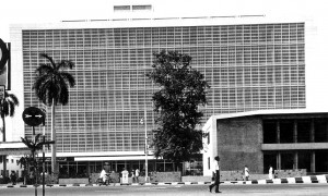 The IOB building in the 1960s.
The central office building of the Indian Overseas Bank is being renovated. I reliably understand that the iconic façade of the building is likely to be replaced by some kind of tinted glass. I have appealed to the current MD to retain the original façade. My appeal is reproduced below:
“As the retired Economist of our Bank and one who played a key role in chronicling the history of it, I seek to submit this humble appeal for your kind and favourable consideration.
You have rightly undertaken the renovation of our iconic Head Office building which was, in fact, overdue. In doing so, I and many like me only hope that the renovated building will retain the iconic façade no matter what material is used or what technology is used. I have attached a photo of the original building taken in the 1960s for your kind information.
Inaugurated in 1964, the iconic Indian Overseas Bank Head Office on Anna Salai was built by L&T’s ECC to a Bennett Pithavadian design. It is believed that the design was aimed at reducing heat and minimising air-conditioning cost. At the inauguration, the then Chairman of the Bank, M.Ct. Muthiah declared, ‘This building symbolises our past performance, our present confidence and our optimism of the future.’ A significant aspect of the building was the provision of a Drive-in Counter with TV facilities at the Cathedral Branch in front of the building which was a first of its kind in India.
Looking forward to your kind consideration.”
Dharmalingam Venugopal
dharmalingamvenu@gmail.com