Registered with the Registrar of Newspapers for India under R.N.I 53640/91
Vol. XXVIII No. 13, October 16-31, 2018
Elevated road, threat to Cooum?
by The Editor
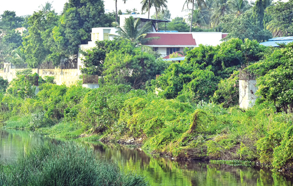
Towers to nowhere on the Cooum River bed. (Photo by R. Raja Pandiyan.)
The elevated road corridor from Maduravoyal to the Harbour is back in the news. A Committee recently reviewed progress on the project with particular reference to the issues of land acquisition.
Earlier in the year, it was decided that the road, planned originally for four lanes, will now be expanded to six. With all this, it appears that the project will take off once more, five years after it was stalled ostensibly for environmental reasons while it was an open secret that the actual cause was political. The story then given out was that the piers for the elevated road were being erected on the Cooum riverbed. This, the Government elected to power in 2011, was unwilling to proceed with and the project was shelved. Now, with the same Party in power, the idea has been revived. As to what happened to concerns regarding the river nobody has a clue.
The project, originally estimated at Rs 1,800 crore, had two major heads of expenditure – construction on the actual roadway at Rs 1,345 crore and the balance to be spent on resettling around 7,000 families and 500 business entities that were likely to be displaced. Spanning 19km, the project when completed was expected to cut commute time for containers and lorries bound for the harbour from anywhere up to 4 hours to just 30 minutes. Repeated delays in the project have however meant that the cost has escalated. The recent decision to expand the road width to six lanes has also impacted plans. The revised cost is expected to be Rs 3,500 crore. The National Highways Authority of India, which is the agency to execute this project, has been pushing for it relentlessly ever since the plan was shelved. Everyone has expressed happiness at the resurrection of the scheme.
What is not clear, however, is as to how the ground reality as far as the Cooum is concerned, has changed. Around two kilometres of the river from Chetput downwards were originally to be the worst impacted. A casual drive down the river in Egmore will reveal several pillars erected on the riverbed, with rusting steel rods sticking out of them. This was the original route, and it came in handy for a newly elected State Government looking for ways and means of cancelling any project closely associated with the previous one. It is interesting that it is the same party that is still in power and is yet keen to revive the shelved scheme.
It is learnt that the Indian Institute of Technology has given a new alignment for the road by the side of the river and with this, piers, around 650 of them, will be on the riverbank and not on the river bed. It has since also been announced that with the new alignment, there will be no necessity to seek coastal regulation zone (CRZ) clearances, as the river will no longer be affected. What is puzzling is the lack of clarity on what exactly is the new alignment.
Those who have the interests of Chennai’s waterways, such as they are, at heart, are concerned at this lack of transparency. It is not all that far back in time that the Mass Rapid Transport System (MRTS) was erected on the Buckingham Canal, thereby finishing off that waterway for good. All talks of its revival ever since have been hollow claims. It has also resulted in several areas becoming permanently prone to flooding each time it rains. If the same blunder is to be made with the Cooum, many more parts of the city can come under water and it could be the making of a first-rate ecological disaster. It is to be hoped that the powers-that-be make their plans transparent, and, more importantly, do a realistic assessment before jumping into the construction.