Registered with the Registrar of Newspapers for India under R.N.I 53640/91
Vol. XXV No. 23, March 16-31, 2016
The eri-s to the South
by Sudha Umashanker
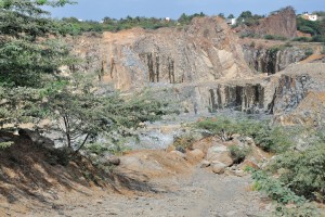
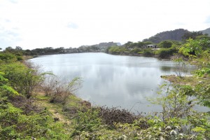
The rocks of Thirusoolam (Left) and its eri (Right).
The hunt for lakes saw me criss-crossing the city once again. My first target was the Thirusoolam eri, but when I got near the airport, the locals sent me off in a different direction (telling me about Royapettah eri and a walking eri – I couldn’t for the life of me figure how there could be a Royapettah eri this side of town). But on a second visit we got it right and it turned out to be such an experience! Driving through huge stone quarries, past what looked like the Grand Canyon, amid dusty, polluted stretches (my heart bled for the people who work in these quarries, the children living there and the kind of occupational hazards they must face), it was a welcome relief to spot the Thirusoolam eri which seemed like an oasis in this barren setting. The eri looked reasonably full. I learnt from a local resident that the eri did not overflow during The Flood. Next, I was at Velachery eri, which had once been fairly large but had now shrunk considerably (it is a mere 55 acres as against 265 acres in the past), what with land being developed left, right and centre. I wonder how many visitors to Phoenix Market City in Chennai are actually aware of the lake just behind the mall. You can get a good view of the lake from the Velachery-Adambakkam road. The lake has a good stock of water. Since Velachery is a low-lying area, rainwater from neighbouring areas drains into it. Today, the water in the lake is highly contaminated, rendering it unfit for drinking, largely because of the release of sewage by the encroachers (who have no issues with directing drainage pipes into the lake). The lake has also breached quite a few times in the past.
 Pallavaram eri.
 Pallikaranai marsh.
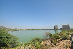
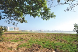
Porur eri spread over 200 acres (it once measured 800 acres) is a temporary catchment linked to the Chembarambakkam eri. While the view from Mount Poonamallee Road appears cleaner, the views from the other sides are not so pretty. This large eri serves as a resource of groundwater for neighbouring localities through infiltration wells. It supplies two million litres of water a day to parts of Chennai and is therefore a buffer source for the city’s drinking water needs. Sadly, it has not been spared from contamination – debris, garbage and sewage on some sides.
 Porur eri.
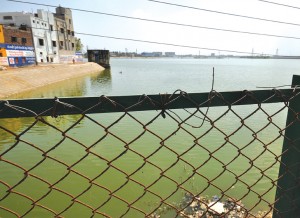
Cruising over the Pallavaram-Thoraipakkam Bridge we stopped to take a look at the Pallavaram eri. Cut into two by the radial road connecting Pallavaram and Thoraipakkam, the lake has been badly polluted, thanks to effluents discharged by leather companies, other wastes, besides water being used for construction. At present, the water appears green and even a quick stop to take pictures is enough for you to be overpowered by the foul odour. Ask any passer-by the name of the eri and chances are that you will draw a blank. (Please, can we have nameboards for our lakes?) Further down is the Kovilambakkam eri.
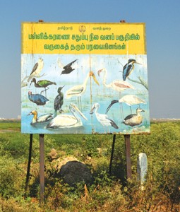 The signage at the Pallikaranai marsh.
At Pallikaranai, sandwiched between the Nandamangalam forest and the Adyar forest, we found herons, flamingoes, a variety of ducks, and long-distance migratory water birds. The marshland is sustained by floodwater received from Velachery Lake and from over 30 tanks before draining out into the Okkiyam Maduvu (channel). While it has suffered due to being classified as wasteland, there is, today, thanks to all the awareness created by activists, a semblance of wanting to protect what little is left of the marshland (even if compromises have had to be made in the name of growth and development and, often, plain ignorance). There are several boards put up by the State Forest Department and Conservation Authority of Pallikaranai requesting people to keep the place clean, not dump garbage, avoid hunting for birds, and not disturb the birds.
Okkiyam Maduvu is a 2.8 km long water channel. It originates as a narrow canal from Pallikaranai and travels towards OMR near Karapakkam, Okiyampet, Thoraipakkam and drains into the Buckingham Canal near Injambakkam through which it empties into the Bay of Bengal. Needless to add, several housing colonies and educational institutions have been developed alongside the channel. The recent rains resulted in flooding of the maduvu.
We reached Moovarasanpettai eri at day’s end (over a month ago) and found the lake dark and dirty. However, recent news reports talk of clean-up efforts being undertaken.
(To be concluded)